A research project using illustration to investigate the history, folklore and landscape of Great Britain's longest river. By combining reportage, archival research and illustration studio practice, my aim is to produce work that encourages an engagement with this environment and the lives (past and present) that are connected to it.
Upton-upon-Severn to the Queenhill Viaduct (M50)
Get link
Facebook
X
Pinterest
Email
Other Apps
I adopted a ‘downstream, upstream’ route for this walk (as I did in Worcester), which fits in with my usual practice when location drawing. I often drift around a location and do a sort of lap, making mental notes of places to draw, before committing to a prolonged drawing. Obviously if something fleeting catches my eye whilst I’m doing this I try to capture it with a sketchbook or camera. My plan for these river walks is that I spot potential drawing sites walking to the mid-point and then engage in drawing on my return.
This stretch of the river is quiet, and the path hugs the bank quite closely passing through farmland and flood plain. The unusual buildings of Upton help create a picturesque view, behind the sheep grazing. There are points of industry along the way-large vessels which I believe carry sand dredged from the river (certainly a subject I will return to draw) and what looks like a water treatment site.
The directional signs that populate certain stretches of water appealed to me-those strong graphic shapes against the green and brown of trees, river, mud and water make interesting compositions. The ‘visual language of the river’ is maybe something to consider here?
This particular concrete monster stretches across the wide green fields and makes the river look like nothing more than a stream. Standing underneath it reminding me of Concrete Island by J.G. Ballard. I was completely alone (apart from a herd of cows eyeing me suspiciously),with the traffic thundering overhead unaware of the land, river (and me) beneath them. The pillars look like skyscrapers and as they curved away into the distance and it gave me the impression of a strange row of abandoned skyscrapers. The walk itself was rather uneventful, and I met few people apart from several fishermen (all men) staring vacantly into the muddy water as the drizzle set in. The weather made me realise a rather obvious limitation of my methodology...paper gets soggy...which makes drawing a little tricky! So, under the cover of the M50 I made my solitary drawing of the day.
Having some sort of umbrella when shelter isn’t available and being less precious with the drawing (working more quickly) will also be ways around this problem. This walk made me realise the importance of having a GoPro capturing the journey. Back in my studio, I could review all the photos, some of which threw up interesting and unexpected viewpoints and compositions, which could make for interesting illustrations. I also like the way it captures the drawing process.
One aspect of walking by the river I am enjoying, is watching the ripples and swirling patterns that the currents generate. Strangely relaxing yet ominous, because I am aware of how dangerous this river is. Whilst walking in the drizzle, I filmed the raindrops as they created circles on the river’s surface. Making simple animated GIFs of the river’s different movements could be an interesting experiment. Exploring that space between illustration and animation seems to be an essential area of study within this project.
When driving back to Malvern from Chepstow in September, I made a quick detour to Lydney Harbour. The ugly industrial area that I passed through didn’t fill me with much hope, but I was pleasantly surprised to find a small harbour filled with an eclectic collection of vessels, some of which seemed to have been stationary for some time. Two huge gates held in the water and gave protection from the Severn’s tides. An Ice Cream van was doing good business and families were strolling around, enjoying the wide views across the Severn. A friendly old chap was engaging as many people as possible, drawing attention to a stone monument that was placed there to commemorate the Severn Railway Bridge disaster. On a foggy night in 1960 two barges collided, creating what must have been an apocalyptic fireball, they then smashed into and destroyed the railway bridge that spanned the river. https://en.wikipedia.org/wiki/Severn_Railway_Bridge I was aware of this terrible event, but having a clear view ...
Walking north from Worcester I followed the Severn Way passing by numerous houses, sunken boats, through meadows and a pub garden (which was unfortunately closed due to the Covid-19 lockdown). A fair variety of trees, other plants and birds on this stretch...and the bright autumnal light helped give the river a more inviting colour than its usual muddy brown. As soon as the paved section of the path ended, I was pretty much alone for the majority of the journey, but there was the occasional walker sliding their way through the mud. The path gets alarmingly close to the water’s edge on several occasions and this along with the mud resulted in a slow, careful pace. Bevere Island has a picturesque weir and a bridge that is on the verge of being considered a ruin. Being on the other side of the river would have helped as it may have given me a better view of the island. The history of this location isn’t necessarily obvious from its appearance but it has reputably been a place of sanc...
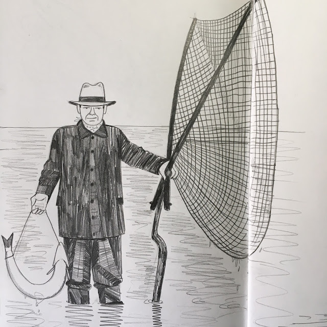
These drawings are made from archive photographs and documentary footage that show the now rare practice of lave net fishing. The moments before and after the photos were taken intrigue me and I can imagine the men wading into the river, then visualising huge salmon leaping into their nets as they stand in the freezing water, hoping for a catch.